|
Home
Up
Search
Multi-County DVDs
Southeast Missouri
Ozark Region
Arkansas Counties
Illinois Counties
Indiana Counties
Iowa Counties
Kansas Counties
Kentucky Counties
Louisiana Parishes
Massachusetts Vital Records
North Carolina Counties
Ohio Counties
Pennsylvania Counties
Tennessee Counties
Texas Counties
Historic Map Reprints
Plat Map Books
Census Records
State County Maps
New Titles
Coming Soon
Questions Answers
Customer Quotes
Wholesale
Conferences
Missouri Journey
Iris Median
Contact Us
Genealogy History News
Special Offers
County History Books
| |
Additional
Free Genealogy and Map Resources
 Camden
County, Missouri
History and Genealogy Camden
County, Missouri
History and Genealogy
More than 110 pages of Camden County, Missouri history
and genealogy including 33 pages of family biographies plus 46 Camden County, Missouri
communities on 16 different maps
An informative and historical overview of Camden County,
Missouri including three separate books on CD which include 16 historical maps
(1851, 1862, 1876, 1888, 1889, 1890, 1899, 1902, 1904, 1911, 1922, 1920's, 1929,
1939, 1948-49, and 1950), plus
the full Camden County, Missouri section from the book: Goodspeed's History of
Camden County, Missouri originally published in 1889. An important resource for
the study and research of Camden County, Missouri history and genealogy.
Fully
searchable - find any name or location instantly!
This fascinating and detailed CD contains ALL of the following material in
three
separate sections, ALL on one CD:
Section One of three, ALL on one CD: The complete 1889
Goodspeed's History of Camden County, Missouri.
This detailed (114 pages in all) book has an incredible amount of historical and
genealogical information
about Camden County, Missouri from its earliest settlement up to 1889. This is an exact
photo replica of all the pages pertaining to Camden County, Missouri including
all of the historical and family biographical information.
Here is just some of the information included:
-
A description of the natural features of Camden County, Missouri
-
Pioneer History of Camden County, Missouri
-
Early settlers and settlements in Camden County, Missouri
-
Establishment of Camden County, Missouri
-
Camden County Circuit Court Transactions
-
Political Record of Camden County, Missouri
-
Camden County Societies and Organizations
-
Camden County Military Affairs (Civil War history) including movements of Union and
Confederate forces and including battles and skirmishes.
-
Camden County Schools
-
Camden County Churches and related organizations
-
History of Cities and Towns of Camden County, Missouri including: Climax Springs * Decaturville *
Linn Creek * Mack's Creek * Oregon ( Erie) * Stoutland * Post Offices.
Included is a 33 page family biographical section with family biographies for each of the
following surnames in Camden County:
To
view a sample family biography, click here
Appleton * Armstrong * Arnhold * Avery * Bollinger * Bowers * Burhans * Chalfant
* Churchill * Darnell * Davis * Debery * Dodson * Earnest * Earp * Estes *
Farmer * Feaster * Francisco * George * Gerhardt * Griesel * Hall * Hooker *
Hopkins * Howard * Kendrick * King * Miller * Moulder * Nelson * O'Halloran *
Osborn * Payne * Pease * Roach * Shubert * Simpson * Stanley * Vincent * Vogel *
Watson * White * Winfrey
In addition to those listed above, more than 1000 other family surnames are
made mention of in the text of the book.
Section Two of three, ALL on one CD: Maps of Camden
County, Missouri
Included here are the central Ozarks of Missouri sections of 16 different
historical maps that include the locations of 46 Camden County settlements:
Map A: A rare 1851 map that shows Camden County, Missouri in its earliest
years. Locations shown: Bensboro * Erie *
Map B: 1862 Camden County, Missouri map (during the Civil War). Locations shown:
Linn Creek * Wet Glaze *
Map C: 1876 Camden County, Missouri map - Shows nine settlements:
Barnumton * Cave Pump * Decaturville * Glaze City * Linn Creek * Little Niangua
* Richland * Stoutville (Stoutland) * Wet Glaze *
Map D: 1888 Camden County, Missouri map - Shows location of 23 settlements:
Auglaize * Banister * Barnumton * Chauncey * Climax Springs * Coelleda * Damsel
* Decaturville * Edith * Fearless * Glaize * Gunter * Linn Creek * Macks Creek *
Montreal * Nonsuch * Osage Iron Works * Purvis * Roach * Sagrada * Stoutland * Wet Glaize * Zebra *
Map E: 1889 Camden County, Missouri map - Shows location of 11 settlements:
Barnumton * Cave Pump * Crittenden * Decaturville * Linn Creek * Little Niangua
* Mack's Creek * Osage Iron Works * Stoutland * Toronto * Wet Glaize *
Map F: 1890 Camden County, Missouri map - Shows location of 18 settlements:
Barnumton * Cave Pump * Chauncey * Climax Springs * Coelleda * Damsel *
Decaturville * Gunter * Linn Creek * Mack's Creek * Montreal * Osage Iron Works
* Roach * Sagrada * Stoutland * Toronto * Wet Glaize * Zebra *
Map G: 1899 Camden County, Missouri map - Shows location of 18 settlements:
Barnumton * Chauncey * Coelleda * Crittenden * Damsel * Decaturville * Glaize *
Hahatonka * Linn Creek * Mack's Creek * Montreal * Osage Iron Works * Purvis *
Spring Valley * Stoutland * Toronto * Wet Glaize * Zebra *
Map H: 1902 Camden County, Missouri map - Shows location of 19 settlements:
Barnumton * Chauncey * Climax Springs * Coelleda * Crittenden * Damsel *
Decaturville * Glaize * Hahatonka * Linncreek (Linn Creek) * Macks Creek *
Montreal * Osage Iron Works * Purvis * Spring Valley * Stoutland * Toronto * Wet Glaize * Zebra *
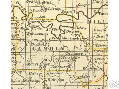
Map I: 1904 Camden County, Missouri map - Shows location of 32 settlements:
Banister * Barnumton * Branch * Carver * Chauncey * Climax Springs * Coelleda *
Corum * Crittenden * Damsel * Debery * Decaturville * Demeter * Edith * Glaize *
Hahatonka * Linncreek (Linn Creek) * Macks Creek * Montreal * Myetta * Nonsuch * Osage Iron Works * Passover *
Purvis * Roach * Sagrada * Springvalley (Spring Valley) * Stoutland * Toronto *
Wet Glaize * Zaring * Zebra *
The 1904 map of Camden County can be viewed here:
Camden County, Missouri 1904 Map
Map J: 1911 Camden County, Missouri map - Shows location of 32 settlements:
Banister * Banner * Barnumton * Branch * Chauncey * Climax Springs * Coelleda *
Crittenden * Damsel * Decaturville * Demeter * Edith * Ganter (Gunter) * Glaize
* Hahatonka * Linncreek (Linn Creek) * Macks Creek * Montreal * Mosier * Nonsuch * Only * Osage Iron Works * Passover
* Purvis * Roach * Sagrada * Springvalley (Spring Valley) * Stoutland * Toronto
* Wet Glaize * Zaring * Zebra *
Map K: 1922 Camden County, Missouri map - Shows location of 22 settlements:
Banister * Barnumton * Damsel * Climax Springs * Coelleda * Crittenden *
Decaturville * Edith * Garnsey * Glaize * Hahatonka * Linncreek (Linn Creek) *
Macks Creek * Montreal * Nonsuch * Osage Iron Works * Purvis * Sagrada * Springvalley (Spring Valley) * Stoutland * Wet
Glaize * Zebra *
Map L: A Camden County, Missouri map from the 1920's which includes details of
where various tourist sites and service stations were located. - Shows location
of 6 settlements:
Branch * Damsel * Linn Creek * Mack's Creek * Roach * Zebra *
Map M: 1929 Camden County, Missouri map from the Missouri Department of
Transportation. You will be amazed at how many of the major routes were only
dirt or gravel! Shows location of 8 settlements: Branch * Decaturville * Hahatonka * Linn Creek * Macks Creek *
Montreal * Stoutland * Zebra *
Map N: 1939 Camden County, Missouri map - Shows location of 11 settlements:
Branch * Camdenton * Decaturville * Hahatonka * Linn Creek * Macks Creek *
Montreal * Neongwah * Stoutland * Sunrise Beach * Zebra *
Map O: 1948-49 Camden County, Missouri map - Shows location of 10 settlements:
Branch * Camdenton * Decaturville * Hahatonka * Linn Creek * Macks Creek *
Montreal * Osage Beach * Stoutland * Sunrise Beach *
Map P: 1950 Camden County, Missouri map - Shows location of 10 settlements:
Branch * Camdenton * Decaturville * Hahatonka * Linn Creek * Macks Creek *
Montreal * Osage Beach * Stoutland * Sunrise Beach *
Section Three of three, ALL on one CD: Camden County,
Missouri in 1913
Included here are four pages concerning Camden County, Missouri from the 1913 edition of
The Missouri Red Book and contains about every imaginable statistic you could
want for this time period. Some of the facts contained are the number of farms
and their acreages, number of cows, horses, mules, pigs, sheep, goats, poultry,
colonies of bees, how many farms had mortgages and how many were free of debt,
the amount of butter produced, the number of bushels of apples, peaches, pears,
etc. harvested, the number of quarts of blackberries harvested, the number of
schools and teachers, plus hundreds of other detailed statistics. A wealth of
information!
Camden County, Missouri is located in the central portion of the Missouri Ozarks and is
surrounded by the following counties: Hickory County,
Missouri * Benton County, Missouri *
Morgan
County, Missouri * Miller County, Missouri *
Pulaski County, Missouri * Laclede County,
Missouri * Dallas County, Missouri (click on
highlighted county names for a complete description)
Each of the three sections on this CD is in Adobe Acrobat pdf format and requires
the free Acrobat Reader program to view. You probably already have this program
on your computer but if not, a free copy of the program is included on the CD.
Each of the books is designed to look just like a regular book and is bookmarked
to move easily and quickly from one section another. This CD was designed by, and is
available exclusively from Hearthstone Legacy Publications.
Fully
searchable - find any name or location instantly!
The cost for this CD containing all three sections described above is only $9.95
plus shipping, or only $4.95 as a digital download! A large amount of history and genealogy information for very
little cost! A truly fascinating view of Camden County, Missouri from its first
settlement to 1889.
Shipping is only $1.95 for First Class Mail in the United States and Canada. If outside of the United States,
please contact us for shipping costs. We accept checks, money orders and all
major credit cards via the shopping cart, mail, or by phone at 816-204-7593.
Speedy Delivery!
We will ship your order within 24 hours of receiving your payment (on first business day if received on weekend or holiday.) We will securely package and ship your order by First Class Mail and you will likely receive in just 2-3 days after ordering! [Shipping can be delayed at times due to weather, holidays, or travel schedules. View our current shipping schedule here: Current Shipping Schedule]
We also offer this CD as a high speed internet download for only $4.95.
Details here:
High Speed Downloads
FREE
sample
family
biography
How to order:
ALL three sections described above are included on one CD for $9.95 plus shipping.
If you wish to pay by credit
card, please use the shopping cart below
(checkout goes to a secure
server.) Credit card orders may also be placed by phone to Hearthstone Legacy Publications from 9 AM to 11 PM (Central Time Zone) Monday thru Saturday at 816-204-7593. If you wish to pay by check or money order, mail $11.90 ($9.95 for
CD plus $1.95 shipping) to:
Hearthstone Legacy Publications
PO Box 466
Branson, MO 65615
Since we offer many different county history
and genealogy CDs, please be sure to specify that you wish to order the Camden County, Missouri History,
Genealogy and Maps
CD. If ordering more than one CD, the shipping cost is $1.95 for the first CD plus only 25 cents
shipping for each additional CD purchased.
For even more value, consider our Southwest Missouri Multi-County DVD which includes all of the contents of this CD (click for details)
This CD is also available as a
high speed internet download. SAVE $$: The download is only
$4.95 ($5.00 less than the CD plus no shipping charges!)
Please read important details here before
ordering as a download:
High Speed Download
. Use the ADD TO CART button BELOW to order as a download:
To view a complete list of Missouri
County History and Genealogy CDs available, click here:
Missouri Counties
Wholesale rates are
available. For details, click here: Wholesale Rates
|