![]()
|
|
|
|
Illinois State 1898 Historic Map Reprint
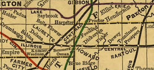
This historic 1898 railroad map reprint shows the county boundaries and settlements within the State of Illinois as it existed in 1898. This map includes the locations of a very large number of small settlements, some of which no longer exist. Due to large number of town names in small print, some magnification is beneficial. An inset of the Chicago area is at the lower left corner.This reprint is of an original railroad map of the State of Illinois by Rand McNally & Company and published in 1898. This map is reproduced as a digital ink jet print in full color, measuring approximately 11.7 x 18.8" centered on 13 x 19" heavy 32 lb paperstock. Our 13 x 19" map sheets are inserted into protective plastic sleeves and mailed rolled in a sturdy mailing tube.(The lower map shows a sample of the detail on this map) |
|
This site features a growing collection of more than 375 Arkansas Illinois Indiana Iowa Kansas Kentucky Louisiana Massachusetts Missouri North Carolina Ohio Tennessee Texas County History and Genealogy titles. Click on the links above or the navigation buttons on the upper left sidebar to view other titles available. Click on the SEARCH tab to search our entire inventory.* * * * * Free Newsletter Would you like to be notified of new publications, new features, upcoming genealogy conferences, plus exclusive special offers and promotions available only to our newsletter subscribers? Subscribers to our FREE newsletter are always the first to know! Sign up for our free newsletter by clicking here Do you enjoy History and Genealogy? Visit: The Lives of Our AncestorsDo you like free? Check out the FREE genealogy and map resources at My Genealogy Hound
Send mail to
Webmaster with
questions or comments about this web site.
|